
History & Heritage
From storied landmarks to quiet roadside markers, Monroe County invites you to experience history where it happened. Stand in the presence of the Cherokee Memorials, journey deep beneath the earth at the awe-inspiring The Lost Sea, and explore the grounds of Fort Loudoun State Historic Park, where the French and Indian War once shaped the frontier. Along winding backroads and scenic byways, historic homes and Civil War traces reveal themselves in unexpected places. Here, every stop tells a story—and every mile brings the past to life.

Driving through history!
Explore Monroe County with ease using our interactive landmarks map. Quickly find national and historic sites, learn a bit of their story, and plan your route—all in one place. It’s the simplest way to discover where to go and what makes each stop worth the visit.
LOST SEA

HERITAGE TRAILS

The Unicoi Turnpike is one of Monroe County's oldest historic routes, beginning as an ancient Cherokee trading path before becoming a toll road in the early 1800s. In 1838, portions of the turnpike became part of the Trail of Tears, as Cherokee detachments were forced west during their removal from their ancestral homeland. Today, these heritage trails preserve centuries of Cherokee history and offer visitors a meaningful opportunity to explore the cultural legacy that helped shape the region.
CHEROHALA SKYWAY

The Cherohala Skyway is Tellico Plains' most iconic landmark and a designated National Scenic Byway, loved for its exceptional natural beauty and scenic driving experience. Opened in 1996, the 43-mile route connects Tellico Plains, Tennessee, with Robbinsville, North Carolina, winding through the Cherokee and Nantahala National Forests and reaching elevations over 5,400 feet. With breathtaking overlooks, waterfalls, hiking trails, and vibrant fall foliage, the Skyway is one of the Southeast's premier scenic destinations, attracting visitors from around the world.
Discover even more local history by visiting our MUSEUM PAGE and exploring the exhibits and stories connected to these landmarks.


Curious about Monroe County’s role in the Civil War?
The Civil War Trail invites you to step into the past and explore the sites where local history was made. As you travel through the county, discover historic markers and locations that tell the stories of people, events, and moments that shaped the region during this pivotal time in American history.
National Register of Historic Places
Please note that the locations are marked on the map above and provided for reference to help you discover the history and significance of each site. Many of these properties are privately owned residences and should be respected as such. Visitors are welcome to admire these historic places from the road, but please do not enter private property or trespass.

Downtown Madisonville
Founded in 1819 as the seat of Monroe County, Madisonville has long been the heart of the county's civic, commercial, and cultural life. Stroll its historic streets to discover beautifully preserved architecture, notable landmarks, and the stories of the people and events that helped shape East Tennessee.

Completed in 1897, the Monroe County Courthouse has served as the center of county government for more than a century. Its striking blend of Romanesque Revival, Classical Revival, and Italianate architecture makes it one of Madisonville's most recognizable landmarks. Today, the courthouse continues to serve the community while anchoring the town's historic square.


The Stickley Mansion
Originally built for Dr. Guilford Cannon,
a prominent local physician, around 1840–1846, the home showcases grand columns, symmetrical design, and classic Greek Revival details. During the Civil War, the residence was reportedly used as a Union headquarters, reflecting Madisonville’s strategic importance during the conflict. Later associated with the Stickley family, the home remains a treasured landmark.


The Kefauver House
Built in the 1830s, the Kefauver House is best known as the childhood residence of Estes Kefauver (1903–1963), who served Tennessee in the U.S. House of Representatives (1939–1949) and the U.S. Senate (1949–1963). Kefauver gained national recognition for leading the televised Senate hearings on organized crime in the early 1950s and was the Democratic nominee for Vice President of the United States in 1956.
_edited.jpg)

Downtown Sweetwater
Established in the 1850s and incorporated in 1875, Sweetwater grew around the railroad and became an important commercial hub for Monroe County. Its historic downtown remains a showcase of well-preserved architecture and the enduring legacy of the businesses and families that helped shape the community.

James M. Pardue House
Standing at the corner of Price and Morris Streets, this historic residence has long been a recognizable part of the surrounding neighborhood. Originally constructed in the 1890s for James and Rebecca Pardue, the home reflects the architectural styles and craftsmanship of its era, contributing to its local historical importance.


Tennessee Military Institute Residential Historic District
Built between 1905 and the early 20th century, the residences housed school administrators and faculty during the institute's most influential years. Originally founded as Sweetwater Military College in 1874, the school became the Tennessee Military Institute in 1902 and relocated to its High Street campus in 1909.


The Hulvey House
Built in 1905 for Colonel Otey C. Hulvey, the Historic Hulvey House was the first residence constructed on "TMI Hill" and is closely connected to the history of the Tennessee Military Institute (TMI). Colonel Hulvey became president of Sweetwater Military College in 1902, renamed it the Tennessee Military Institute, and led its relocation to a new campus in 1909. The home, with its distinctive wraparound porch, remains a landmark of Sweetwater's educational heritage and is privately owned today, preserving memorabilia from Colonel Hulvey and TMI's early years..
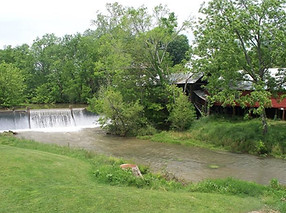

William J. Fowler Mill & House
Located near the intersection of Loudon Road and Eve Mill Road. The property is part of a larger farmstead established in 1824 and represents the region’s agricultural and milling heritage. William J. Fowler Jr. was a prominent local figure who served in the Tennessee State Legislature and helped establish Tulogahler College. The existing mill was built in 1875 on the site of an earlier Eve Mill and produced meal and whole wheat flour using a Meadows 24-inch mill installed in 1947 and powered by a Samson turbine. Although the mill ceased operations in the 1990s, much of the original milling equipment remains intact inside the structure.

The First Presbyterian Church
As Sweetwater flourished during the railroad era, First Presbyterian Church rose alongside it in 1888. Built in the Gothic Revival style, the church's striking bell tower, lancet windows, and fine craftsmanship have watched over generations of worshippers and remain a lasting reminder of the town's rich architectural and spiritual heritage.

Charles Owen House
Built in 1827, the Charles Owen House is among Sweetwater's oldest surviving homes. Originally constructed in the Federal style, the residence was later enhanced with distinctive Queen Anne features. Home to Charles Owen—a respected farmer, businessman, Presbyterian elder, and anti-slavery advocate—the property remains an important landmark in Sweetwater's early history.

John McCroskey House
Built between 1852 and 1857, the John McCroskey House was constructed of handmade brick on a limestone foundation, the two-story home retains its original central hall floor plan, fireplaces, and many historic features. John McCroskey, Monroe County's first sheriff and a prominent farmer and landowner, built the residence on his rural estate east of Sweetwater.
Vonore Tennessee
Located along the Little Tennessee and Tellico Rivers, Vonore’s history reaches back thousands of years. The area was once home to the Cherokee towns of Tanasi and Chota, important Overhill Cherokee communities that existed before European settlement. In 1756, Fort Loudoun was built by the British during the French and Indian War, becoming one of the earliest European forts west of the Appalachian Mountains. Established as a town in 1911, Vonore continues to preserve its rich Cherokee, pioneer, and river heritage through historic landmarks including Sequoyah Birthplace Museum.


_edited.jpg)
Chota and Tanasi Cherokee Village Sites
The Chota and Tanasi Cherokee Village Sites are listed on the National Register of Historic Places, recognizing their significance in Tennessee’s Native American history. Located along the shores of Tellico Lake, these historic Cherokee communities played an important role in the region’s cultural and political landscape. Tanasi is recognized as the namesake of the state of Tennessee, while Chota served as a principal Cherokee town and center of leadership during the 18th century.
The Citico Cherokee Village Site
Located beneath the waters of Tellico Lake near present-day Citico Beach and the Harrison Branch area, the Citico Cherokee Village Site was once one of the largest Overhill Cherokee towns. Situated along the Little Tennessee River near the mouth of Citico Creek, it served as an important center of Cherokee life and culture while preserving archaeological evidence of centuries of Native American settlement. Unlike nearby Chota and Tanasi, Citico does not have a developed public memorial site; its history is shared through interpretive resources and nearby heritage attractions.


The Mialoquo Village Site
An important Overhill Cherokee town site recognized for its archaeological and historical significance. The site is associated with important Cherokee leaders, including Dragging Canoe, and provides valuable evidence of both prehistoric Mississippian culture and historic Cherokee settlement. Its archaeological remains contribute to the understanding of Cherokee political, military, and cultural history in the Little Tennessee River Valley. Before the creation of Tellico Lake, the village was located along the Little Tennessee River, just beyond the railroad bridge on the south side of the river near the mouth of Mialoquo Creek.
The Tomotley Village Site
Located along the Little Tennessee River, the Tomotley Site was an important Overhill Cherokee town that played a role in Cherokee diplomacy and colonial history during the French and Indian War. In 1756, Cherokee leaders welcomed British forces who arrived to establish nearby Fort Loudoun, making Tomotley a significant location during a period of growing tensions between British and French alliances.
Archaeological excavations uncovered the remains of a Cherokee councilhouse, 19 structures, human burials, and thousands of artifacts revealing centuries of Native American occupation. Evidence shows the site was inhabited as early as the Archaic period (8000–1000 B.C.), with major periods of occupation during the Mississippian culture period and the 18th-century Overhill Cherokee era. Before the creation of Tellico Lake, the village was located along the south bank of the Little Tennessee River, just north of the mouth of Toqua Creek.


The Toqua Village Site
A Mississippian-period settlement and an 18th-century Overhill Cherokee town. Located along the Little Tennessee River near present-day Monroe County, Toqua means “place of a mythic great fish” in Cherokee. Archaeological excavations revealed two ancient mounds, village structures, burials, and artifacts dating back to the Dallas culture (A.D. 1200–1600) and later Cherokee occupation. Before the creation of Tellico Lake, the site was extensively studied, preserving valuable information about Native American history, culture, and community life in the region.
Icehouse Bottom Site
Archaeological site located beneath the waters of Tellico Lake near Vonore. Before the creation of the lake, the site occupied the south bank of the Little Tennessee River near Rockcrusher Bluff and the McGhee-Carson area. Recognized as one of the oldest and most important Archaic-period Native American sites in the United States, Icehouse Bottom preserves evidence of human habitation dating back to 7500 B.C. during the Late Archaic period—more than 9,000 years ago. Archaeological excavations uncovered artifacts that provide valuable insight into early hunter-gatherer communities, the development of agriculture, and extensive trade networks across prehistoric North America.


Tellico Blockhouse Site
Recognized for its role in early American military history and Cherokee relations. Built in 1794 along the Little Tennessee River, the blockhouse served as a U.S. military outpost, government post, and meeting place for negotiations between American officials and Cherokee leaders. Today, the site preserves archaeological remains and reconstructed foundations that tell the story of frontier life, diplomacy, and the changing relationship between the United States and the Cherokee Nation.

Fort Loudoun
Built by the British between 1756 and 1757 during the French and Indian War, Fort Loudoun served as the westernmost British frontier fort and an important military and diplomatic outpost. Following the 1760 Siege of Fort Loudoun, the fort was surrendered, abandoned, and ultimately destroyed. Today, archaeological remains and a reconstructed fort preserve the story of this significant landmark and its role in shaping the history of East Tennessee and relations between the British and the Cherokee.

Downtown Tellico Plains
Established in 1911, Tellico Plains grew from a mountain settlement into a thriving lumber community shaped by the surrounding forests, Tellico River, and Appalachian landscape. Today, its historic downtown offers a glimpse into the town’s past, preserving the stories and traditions that have defined this mountain community for generations.

The Scott Mansion
The Scott Mansion in Tellico Plains reflects the growth and prosperity of the community during the early 20th century. Born in Johnson County, Tennessee, Charles Abner Scott came to Tellico Plains around 1890 and helped shape the town’s development by expanding his land holdings, recruiting the Stokely Company, supporting local education, and introducing innovative agricultural practices.
Between 1908 and 1912, Scott built the impressive Neo-Classical Revival mansion, which remains the centerpiece of the property today. In 2016, Jill and Major David Lemanowicz began a new chapter for the historic farm, restoring the mansion and preserving the surrounding 200-acre working farm. Today, Scott Mansion Farms celebrates Tellico Plains’ agricultural heritage through special events, community gatherings, and overnight stays in a cozy cottage overlooking the beautiful Unicoi Mountains.
